The 1,000-Mile Great Lakes Adventures

Showing posts with label upper peninsula. Show all posts

Sunday, August 6, 2017

Hiawatha Club

Loreen Niewenhuis is an author, adventurer, and dynamic speaker. 

She has completed a trilogy of 1,000-mile adventures exploring the Great Lakes and has authored three books about these adventures: 

A 1,000-Mile Walk on the Beach  [A Heartland Indie Bestseller]

A 1,000-Mile Great Lakes Walk   [Winner of the Great Lakes Great Reads Award] 

A 1,000-Mile Great Lakes Island Adventure  [Long-listed for the Chautauqua Prize]


To learn more about her work, or to engage her as a speaker, go to http://www.laketrek.com/great-lakes-speaker/


Last month I had the pleasure of speaking at the Hiawatha Sportsman's Club
in Michigan's Upper Peninsula.


The club has existed for 90 years and encompasses over 36,000 acres 
including 6 miles of Lake Michigan shoreline.


Manitou Lodge Museum


I spoke in the Manitou Lodge Museum which is perched on a hill overlooking Lake Michigan.


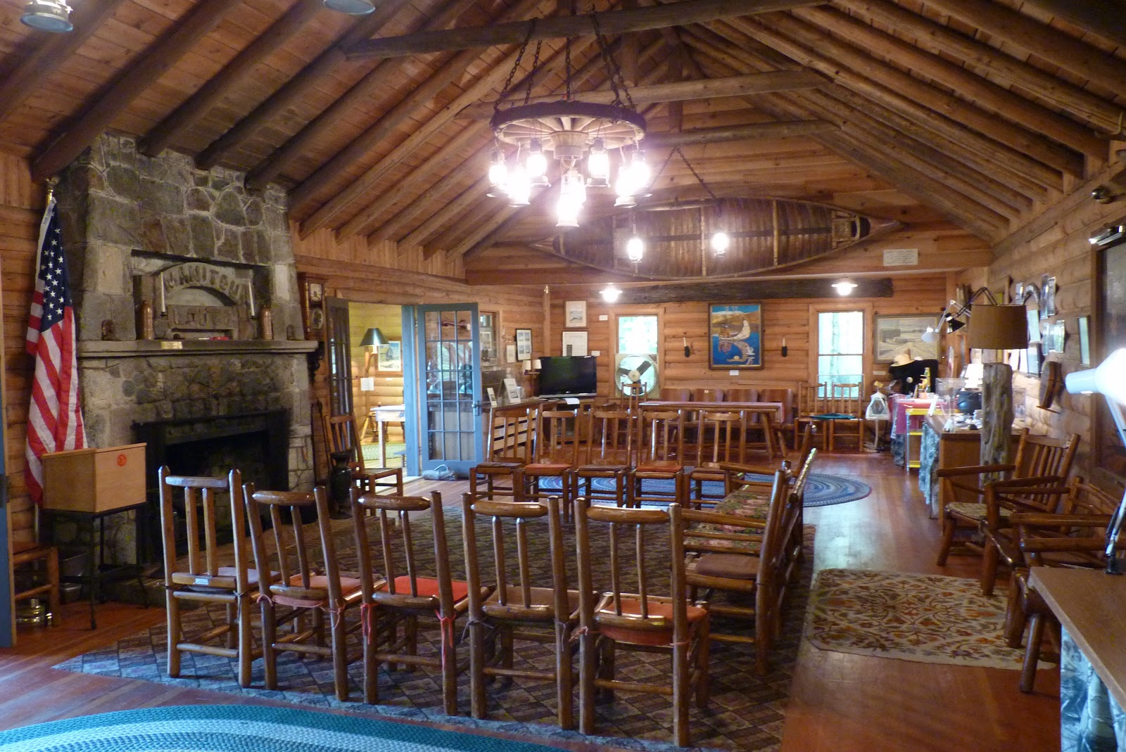
The museum chronicles the foundation of the club by Dr. William McNamara and the natural history of this land.


The land was stripped of trees in the early 1900s


A wonderful audience awaits my presentation on the islands of our Great Lakes


Sunday, May 29, 2016

Eastern Upper Peninsula Tour

Loreen Niewenhuis is an author, adventurer, and Great Lakes speaker. She has completed a trilogy of 1,000-mile adventures exploring the Great Lakes and has written three books about the Great Lakes [A 1,000-Mile Walk on the Beach *a Heartland Indie Bestseller*A 1,000-Mile Great Lakes Walk *winner of the Great Lakes Great Reads Award*, and A 1,000-Mile Great Lakes Island Adventure]. To learn more about her work, or to book her as a speaker, go to http://LakeTrek.com


After my time hiking Isle Royale with a MooseWatch Team (which I'll blog about soon), I spoke at three libraries in the eastern U.P.

Bayliss Public Library is in Sault Ste. Marie, so I spent some time watching the freighters move through the Soo Locks.


Best snack spread ever!


Audience at Bayliss


With Head Librarian of Les Cheneaux Library, Jane French

Audience at Les Cheneaux Library

And I had a third engagement at Engadine Public Library. Thanks to everyone who came out to hear about the islands of our Great Lakes.

Tuesday, August 7, 2012

Thimble Berries and Petroglyphs

While hiking along Lake Superior near Copper Harbor, the thimble berries were in bloom.  

Ben and I stopped to pick them along the way.


The leaf of the thimble berry plant is quite distinctive...


...as is the berry, so mistakes in identifying them...


...are rarely made...just kidding!  They were delicious!


A friend in Copper Harbor directed our hike to an area nearby that had petroglyphs (carving on stones). The authenticity and dating of some of these is still in question, but one of them (the ship) is now protected under glass.  For a better photo of and more information about these petroglyphs click HERE or HERE

This house petroglyph looked rather recent


This ship may tell the tale of the copper trade through this area over a three thousand years ago


A "sungod" symbol (circle with cross) and a figure with a bird head


Friday, July 24, 2009

Segment 8 Day 1 Escanaba->Fox Park camping 16 miles


High of 70 degrees.
July 14

After just two days off, I began hiking south from Escanaba along the edge of Green Bay. The water level in the bay (and in Lake Michigan) is still down from the high levels in the mid-1980s. This really shows on the bay shoreline. There is often a strip of sand marking the former high water mark and a wide swath of water plants growing in the muck out to the lower water level.

The summer monarchs were dying off and their offspring were munching on the milkweed plants along the way. The monarchs that will migrate to Mexico this fall are several generations removed from the ones that migrated up from Mexico this spring. Amazing.

Oh, and I found D.B. Cooper. South of Escanaba. That's all I'm saying...

Tuesday, July 7, 2009

Segment 7 Day 6 Manistique->mid Garden Peninsula 15 miles


High of 65 degrees. July 7

I began this day's walk in Manistique along the boardwalk along the shore. Phil (in first photo) walked with me to the lighthouse, then I continued on across the Manistique River and toward the Garden Peninsula.

Manistique--like many coastal Michigan towns--was a major lumbering town in the late 1800s to early 1900s. Even today, there are still deposits of sawdust and woodchips in the lake and on the shore. There are even rough sawn lumber planks that still wash up after storms. It is estimated that over 5 million tons of sawdust were produced during the lumbering years in Manistique, and most of it was dumped into the lake.

I walked the lakeshore on some of these sawdust deposits (third photo above), then over limestone, then onto some sandy stretches before heading inland just a bit to head down the Garden Peninsula on a road. This peninsula has a lot of limestone. After I hiked most of the day, Phil picked me up and we crossed to the west side to Fayette State Park (last photo above). This park is the site of an iron ore refinery that operated for a brief period just after the Civil War. It was the perfect site since the limestone was used to purify the ore, there were hardwood forests to cut in order to make charcoal, and there is a deep water harbor for the ore boats.

Monday, July 6, 2009

Segment 7, Day 5 Seul Choix->Manistique 15 miles


High of 60 degrees. July 6

There is a large limestone quarry between Gould City Township Park, and there is no easy way to get around it. So, this day began just west of the quarry at Seul Choix Point (pronounced ses shwa which means 'only choice' in french). There is a gorgeous lighthouse there which is my brother Phil's favorite. He has spent some time the last couple of days photographing lighthouses in the Upper Peninsula while I've been on the Lake Trek.


This day's 15 miles was a fascinating hike because the point at which I began was a limestone outcropping shoreline which transitioned into a wide, sandy beach with rolling dunes, then back to limestone mixed with wetlands. It was a walking, climbing, wading lesson in geology.

Segment 7, Day 4 Nabinway->Gould City Park 19 miles


High of 75 degrees. July 5

I had planned on walking the shore from Nabinway to the park south of Gould City, but the weather did not cooperate. The lake is still pretty cold now, and this day warmed up quickly. This led to thick fog rolling in off the lake.

My hike from Muskegon to Montague was foggy, and it didn't derail the hike because the beach there is broad and sandy. The shoreline along today's hike, though, was a mixture of wetlands, bogs, and rocky shore.

I've learned how to read the vegetation in wetlands so I know where to walk. Here's how I learned:

1. Sink in muck.
2. Take note of vegetation around sinking self.
3. Avoid areas around that vegetation in the future.

Okay, it's not all that scientific, but it seems to work.

With the thick fog, I couldn't pick my way safely through these areas, so I opted to walk Route 2 west, then south on Gould City Road. This turned my 15 mile day into a 19 mile day, but it was the right decision.

I dislike being away from the lake, but I found myself taking time to do things like chew on grass and drink the nectar from clover blooms (pull the petals, suck on the white ends--it will make you understand the life of bees), and watch the wind blow a field of hay.

I've had a couple of hitchhikers along the way. The photo below is of a tick I discovered before it bit me.

Friday, July 3, 2009

Segment 7, Day 1 St. Ignace ->south of Brevort 15 miles

High of 70 degrees.

July 2


After spending a few days on Mackinac Island with my sons, I took the ferry to the city of St. Ignace on Michigan's Upper Peninsula to begin Segment 7. Lake Huron and Lake Michigan are connected at the Straits of Mackinac. The bridge that spans the peninsulas is the marker which divides the lakes. The Mackinac Bridge is an elegant suspension bridge which spans the 5 miles of fast moving water. When it was built in 1957, it was the longest suspension bridge in the world.

It felt good to get back to the lake. This day's trek stayed on lakeside roads for most of the way since the shoreline was marshy most of the way. It was only at the end of the 15 miles that the lake opened up to beautiful beaches.